El Niño Could Ignite Eastern Pacific Hurricane Season in 2026
Experts warn that El Niño is likely to develop by summer 2026, creating warmer waters and reduced wind shear that could amplify the Eastern Pacific hurricane season — increasing the risk of more frequent and rapidly intensifying storms.
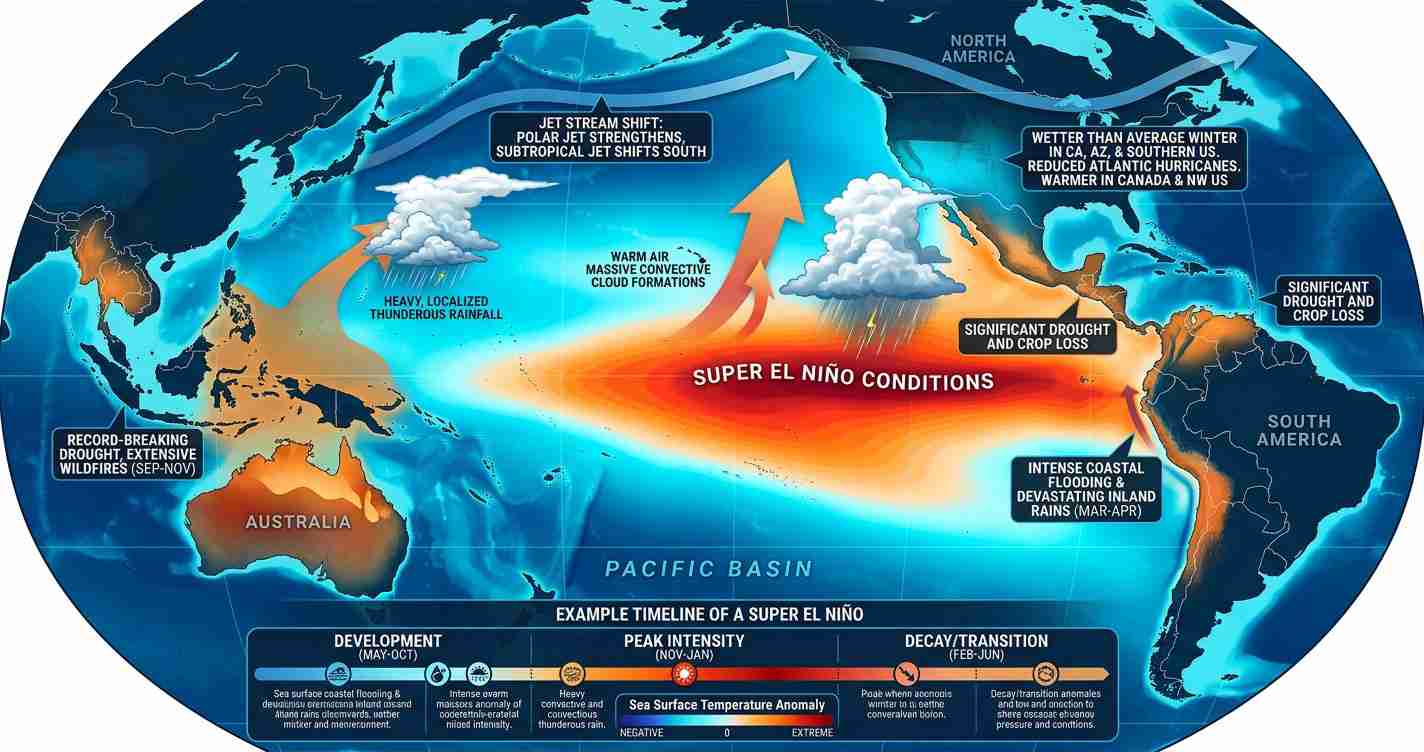
- El Niño chances: Climate models give about a 61% chance of El Niño forming May–July 2026 and ~25% chance of a Super El Niño by fall.
- Pacific boost: Warmer sea surface temperatures and reduced local shear can produce more storms and raise rapid intensification potential.
- U.S. impacts: Indirect effects include disrupted Pacific trade, surf and heavy-rain risk on the West Coast and Hawaii, and increased pressure on emergency preparedness.
Current conditions and timing
ENSO currently sits near neutral but is trending warmer, which favors El Niño formation heading into summer 2026. Multiple climate models, including those cited in Time: “Super El Niño 2026: What to know”, place the highest odds of development between May and July. An early onset — before mid-summer — would give El Niño more time to shape seasonal patterns in the Eastern Pacific; a later onset (after August) could allow more early Atlantic/Gulf activity before Pacific conditions fully shift.
Mechanism: why El Niño fuels Eastern Pacific storms
El Niño alters oceanic and atmospheric conditions in several ways that favor stronger Pacific hurricane seasons:
- Ocean heat and convection: El Niño raises sea surface temperatures across the central and eastern equatorial Pacific, producing more evaporation and moisture that fuels deep convection. Sea surface temperatures are already 1–3°F above long-term averages in parts of the Pacific, giving storms added energy (Fox Weather).
- Wind shear dynamics: While El Niño tends to increase upper-level winds and vertical shear in the Atlantic (suppressing storms there), the Eastern Pacific often experiences reduced local shear, allowing storms to stay vertically stacked and organize more easily (AccuWeather).
- Rapid intensification potential: When warm surface waters overlay deep, warm subsurface layers, storms can undergo sudden strengthening. Recent Eastern Pacific events have shown rapid intensification is a real and growing operational concern (Fox Weather).
Why it’s likely to ignite the season
Several compounding factors make the Eastern Pacific especially sensitive to El Niño in 2026:
- Elevated ocean heat content: Key Pacific regions are already above average, raising the baseline energy for storm formation (Fox Weather).
- Reduced shear: Local upper-level winds in the Eastern Pacific often relax during El Niño, aiding storm development (AccuWeather).
- History of rapid intensification: Recent seasons demonstrate how quickly storms can strengthen when conditions align, increasing forecasting urgency (Fox Weather).
“A stronger El Niño typically correlates with a more active and intense Eastern Pacific hurricane season.”
Forecast outlook and probabilities
NOAA and multiple climate models currently favor El Niño development for late spring to summer 2026, assigning roughly a 61% chance for development between May and July and about a 25% chance it could become a Super El Niño by fall — a scenario associated with outsized global impacts and a higher probability of intense Eastern Pacific activity (Time).
Historical precedent and expected activity
Past El Niño years commonly show above-average Eastern Pacific activity. Since 1990, seasons with at least moderate El Niño conditions have been tied to an increased likelihood — in some summaries approaching ~85% — of above-average activity. Typical El Niño-year averages often approach ~17 named storms, ~9 hurricanes, and ~5 major hurricanes versus baseline averages of 15, 8, and 4 (Fox Weather; YouTube overview).
Season timeline and watch points
The Eastern Pacific hurricane season runs May 15–November 30, with peak activity from July through October. The first named storm often forms by mid-June; early El Niño development could shift the schedule earlier or increase intensity once storms begin. Monitoring sea surface temperatures and upper-air wind patterns through June and July will be critical for refining outlooks (2026 Pacific hurricane season (seasonal reference)).
Contributing factors beyond El Niño
El Niño is a major driver but not the only one. Climate patterns such as the Pacific Decadal Oscillation (PDO) can create multi-year sea surface temperature shifts that compound El Niño’s effects. Some analyses suggest a positive PDO phase that favors warmer-than-average Pacific waters and could magnify seasonal responses (Wikipedia).
Implications for the United States
Economic and infrastructure concerns: A more active Eastern Pacific season may produce more intense storms near Mexico and Central America, disrupting trade, shipping lanes, and Pacific coastal economies. U.S. ports, fisheries, and shipping along the West Coast and Hawaii could face operational interruptions and higher insurance claims.
Public safety and preparedness: Rapid intensification reduces lead time for warnings and evacuations. Emergency managers should update response plans, communication strategies, and public education on evacuation routes, emergency kits, and flood insurance choices.
Political and budgetary effects: Leaders will face pressure to fund preparedness and resilient infrastructure — prioritized, accountable investments like hardened ports, improved drainage, and stronger communications that lower long-term costs.
Agriculture and commerce: Heavy rainfall and storm-driven flooding can affect crops and supply chains in Mexico and Central America, with ripple effects on U.S. food imports and prices.
Operational forecasting and response: The potential for a Super El Niño highlights the value of expanded ocean monitoring, more frequent satellite and buoy data, and improved modeling to better anticipate rapid intensification.
Daily life and communities: While direct landfalls most often affect Mexico and Central America, U.S. communities may experience surf, moisture surges, and coastal erosion; residents should monitor official forecasts during peak months and review personal preparedness measures.