Iceberg A‑23A disintegration: Reagan‑era megaberg nears collapse, offers clues to Antarctic megaberg science
Iceberg A‑23A, a tabular megaberg that calved from the Filchner–Ronne Ice Shelf in 1986, is rapidly disintegrating in the South Atlantic, covered in melt ponds and nearing complete breakup while scientists track its collapse for polar‑ice insights.
- Decades‑long story: A‑23A calved in 1986, grounded for decades, then drifted north and began fragmenting after 2023.
- Rapid shrinkage: From ~4,000 km² at formation to an estimated ~1,182 km² (456 mi²) by early January 2026 (U.S. National Ice Center estimate).
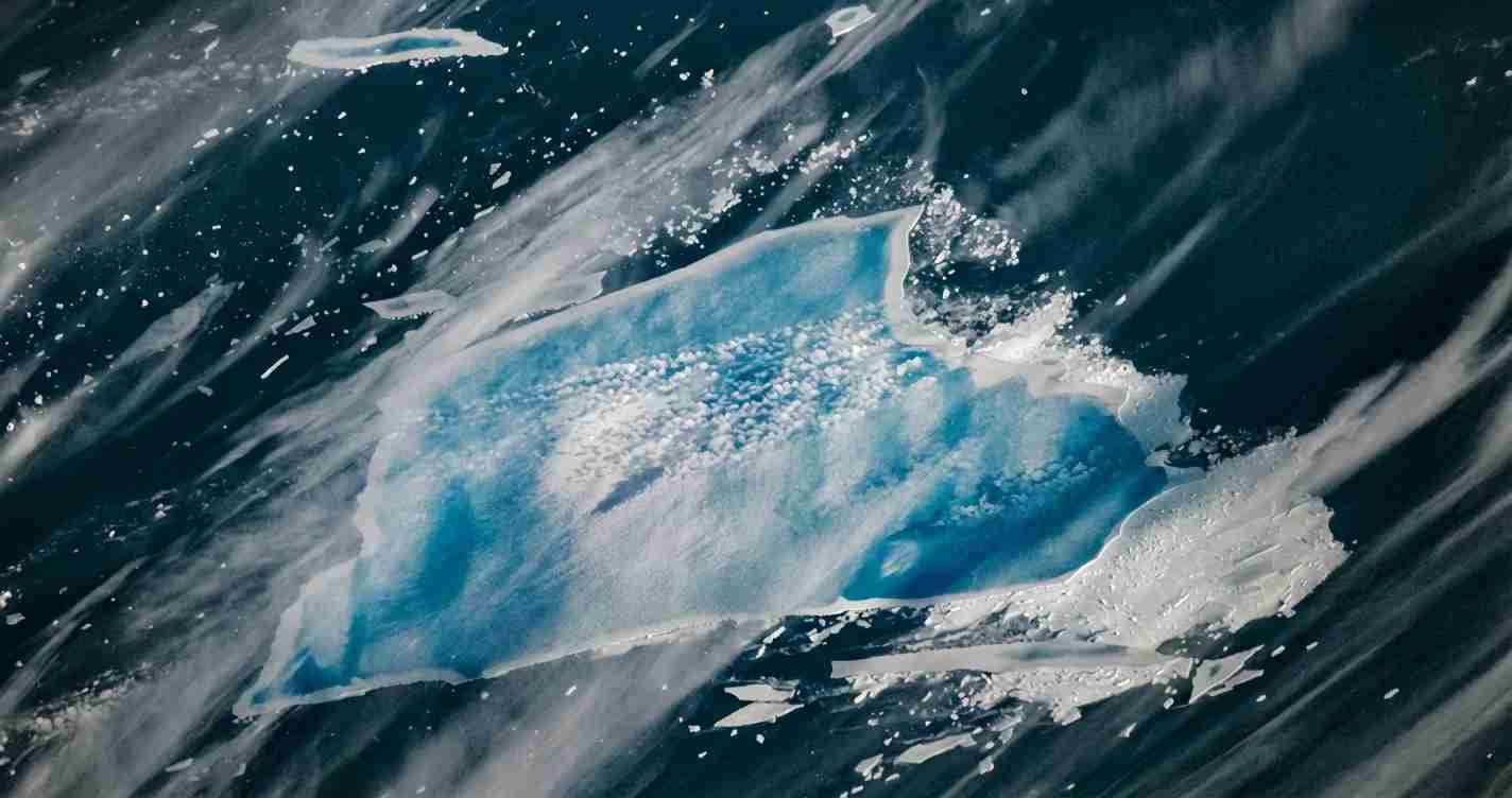
- Melt processes visible: Extensive blue melt ponds, blowouts and freshwater plumes are accelerating mechanical breakup.
- Scientific value: International satellite, shipboard and field data are informing iceberg‑melt, ocean stratification and ecosystem models.
Overview
Iceberg A‑23A is a large tabular (flat‑topped) iceberg that calved from the Filchner–Ronne Ice Shelf in 1986. It was nearly twice the size of Rhode Island at formation (~4,000 km²) and later became, at times, the world’s largest tracked iceberg. Recent satellite imagery shows the berg heavily waterlogged, riddled with melt ponds and structural weaknesses as it drifts in the South Atlantic between the eastern tip of South America and South Georgia Island.
History and long grounding
Soon after calving, A‑23A grounded on the shallow seabed of the Weddell Sea and remained largely immobile for more than three decades. Grounding on a shallow shelf kept it from open‑ocean exposure and slowed melting, making the berg a persistent feature in Antarctic satellite time series. The British Antarctic Survey documents the berg’s extended grounding and eventual escape into open waters.
Key references: British Antarctic Survey, EUMETSAT case study.
Escape, drift north and the Taylor‑column episode
Around 2020 A‑23A finally broke free and began a slow northward drift. By late 2023 it had passed the northern tip of the Antarctic Peninsula and entered the open Southern Ocean, tracked by satellite systems from ESA, NOAA and others. In early 2024 the berg became caught above Pirie Bank in a Taylor column — an oceanographic steady‑flow feature — where it orbited nearly in place and rotated roughly 15° per day. That episode delayed its move into warmer waters until late 2024.
References: British Antarctic Survey, NOAA NESDIS.
Approach to South Georgia and rapid breakup
Prediction met reality: Scientists warned that A‑23A would fragment in warmer, rougher seas north of South Georgia Island. In 2025 the berg shed very large pieces — some reported as big as 400 km² — and subsequently fragmented through consecutive summer calving events. Satellite analyses show rapid decline from roughly 3,500 km² in early 2025 to many smaller fragments by late 2025.
Sources: Wikipedia — A23a, additional reporting summaries documented in international media and scientific posts.
Blue melt ponds, blowouts and mechanical breakup
NASA Terra MODIS captured compelling images on Dec. 26, 2025 showing extensive blue meltwater ponds; an astronaut aboard the International Space Station photographed larger connected ponds the next day. The blue hue indicates ponded freshwater penetrating cracks and porous layers. Glaciologist Ted Scambos notes that the weight of such water can force cracks open, magnifying fracture growth and accelerating breakup.
“The weight of meltwater can force cracks open and make fractures grow,” — Ted Scambos.
NASA described rampart–moat patterns and linear bands that trace old glacial striations now channeling meltwater. Imagery also shows blowouts — sudden releases of ponded water that create freshwater and ice plumes, altering surface salinity and delivering mineral‑rich ice to the ocean surface.
Reference: NASA Earth Observatory.
Why A‑23A matters to science
A‑23A is a rare natural experiment: one of the largest and longest‑lived icebergs tracked with modern satellites and samplings. International teams — including NASA, British Antarctic Survey and other agencies — use satellite, shipboard and in‑situ observations to refine models of iceberg drift, melt physics and impacts on ocean circulation, nutrients and ecosystems.
Tracking, hazards and maritime concerns
Even as it fragments, A‑23A and its pieces remain navigational hazards. Agencies including NOAA NESDIS, EUMETSAT and national ice centers issue advisories and imagery to warn mariners and shipping interests.
Implications for the United States
Economic impact
Direct effects on U.S. ports are minimal, but Southern Ocean iceberg events can shift fish stocks and shipping patterns that feed global markets. Changes in Antarctic productivity from freshwater and nutrient inputs may indirectly influence U.S. seafood prices and supply chains.
Policy, security and science
For policymakers, A‑23A’s disintegration underscores the value of continued investment in satellites and polar research. Moderate, practical funding for observation programs (NASA, NOAA) strengthens national security, commerce and scientific forecasting. The U.S. Navy, Coast Guard and commercial operators monitor large iceberg events for navigational risk and situational awareness.
Practical actions: mariners should follow ice charts and advisories; policymakers can review support for Earth‑observing satellites; and industry leaders should assess supply‑chain risk tied to Southern Ocean changes.
Status snapshot and recent estimate
After multiple breakups in mid‑ to late‑2025, the U.S. National Ice Center estimated A‑23A’s remaining area at about 1,182 km² (456 mi²) in early January 2026. The berg remains larger than many cities — NASA noted it was still larger than New York City at that estimate — but its heavily waterlogged state and widespread melt ponds point to likely full disintegration within weeks to months.